Environmental data collection with high spatial resolution represents the essence of much scientific research aimed at studying the areas in which we live.
Among the data collected, meteorological data stands out.
In various contexts, its variability across extended areas is such that the data from ordinary fixed station networks is not capable of providing the necessary information that only systems able to acquire data with a spatial resolution of just a few metres can offer.

Thanks to its speed, its ease of use and the accuracy of its measurements, MeteoTracker represents the ideal solution for scientific projects. Especially when a massive, systematic, and spatially continuous collection of meteorological data is required. It has a special propensity for Citizen Science, where citizens take an active role in collecting environmental data in the area in which they live.
MeteoTracker has been selected in many important European (I-CHANGE, CityClim, Urban Watch) and academic projects (Politecnico di Torino, Leipzeig, Firenze and Bologna universities) with more than 400 units deployed in the field.
The MeteoTracker measurements allow for unprecedented ground-truth data to be used in weather forecast modelling at hyper-local scales.
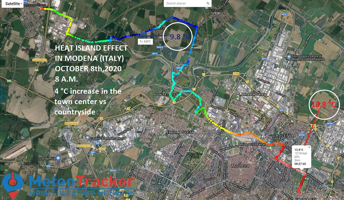
URBAN HEAT ISLANDS
With MeteoTracker, carrying out accurate thermo-hygrometric (plus other 6 parameters) scans with a resolution of just a few metres is straightforward.
In the standalone version data collection is fully automated, and the ease of use of the smartphone solution makes MeteoTracker the ideal solution for Citizen Science projects aimed at the study of urban micro/nano climates.
The very high measurement speed means rapid thermal variations that are often encountered in urban areas, even over very short distances, can be captured with precision, allowing us to create very accurate datasets.
AIR POLLUTION
Air pollution is closely linked to the micro-meteorological parameters that are present in any given area. For example, the greater the thermal inversion, the greater the concentration of pollutants.
Therefore, a mobile network for acquiring meteorological data with high spatial resolution, capable of mapping the thermo-hygrometric profile to a level of detail of just a few metres, in an urban or industrial context, is an important asset for planning actions to combat and reduce air pollution.
MeteoTracker offers a solution that enables this in a quick and accurate way, at a competitive cost.
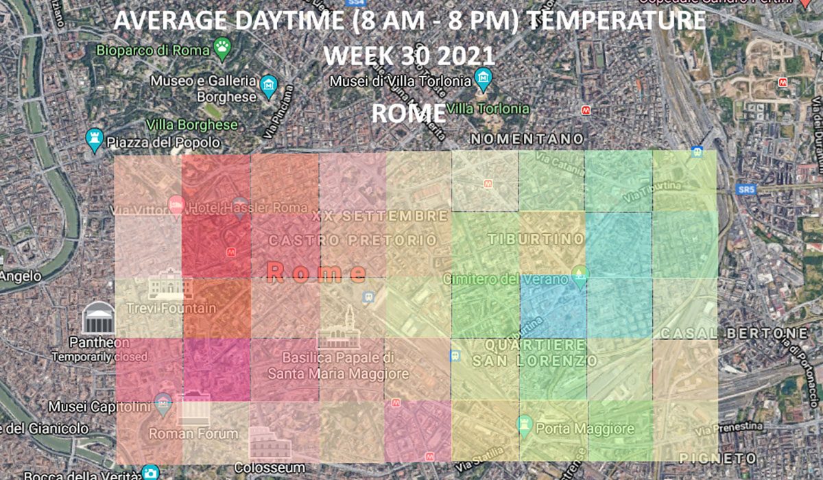
THERMAL COMFORT MAPS
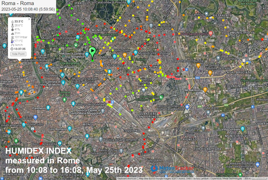
Temperature, humidity, pressure, solar radiation intensity.
These are parameters that determine the thermal comfort of any given geographic area. They can be acquired in a spatially continuous way using MeteoTracker, to provide a detailed characterisation of the area.
In this way, it is possible to prepare thermal comfort maps in real-time, which can be used by the public.
MeteoTracker measures 8 weather parameters, including a thermal comfort index (humidex), from which maps of thermal comfort can be implemented.
A thermal comfort map enables the identification of urban areas more or less exposed to conditions of thermal discomfort, allowing the analysis of the impact of the different urban fabric structures, of the soil nature and of the urban greenery on the climate quality of a metropolitan area.
The MeteoTracker map module – easily embeddable in the every third party web site – can be used to make available to the citizens an easy interface for real-time visualisation of the thermal comfort distribution in a given geographical area.
THE STUDY OF MICROCLIMATES IN SENSITIVE AREAS
The microclimate and nano-climate in humid, coastal areas, forests or mountain valleys and other eco-sensitive zones is often at the centre of scientific research studies. Knowledge of this is increasingly important in the light of the rapid climate change we are experiencing.
With MeteoTracker, the automatic and spatially continuous acquisition of meteorological data would enable you to create extremely detailed thermo-hygrometric maps of the areas being studied.
SCIENTIFIC EXPEDITIONS
MeteoTracker is a vital instrument for scientific expeditions and environmental study projects that often take researchers into extreme environments.
Thanks to the patented RECS system, its temperature measurements are always accurate, even in conditions of strong solar radiation and at low speed.
Atmospheric pressure and dew point help to predict weather patterns.
Knowledge of the thermal comfort index over time can prevent long exposure to conditions that are dangerous to the body.
The long battery life and the functionality of the smartphone as a data-logger enable autonomous data acquisition for more then 20 days.
ATMOSPHERIC PHYSICS AND MODELLING
The data assimilation phase is vital to the quality of a weather forecast.
In modelling on a local or hyperlocal-scale, the availability of weather observations with sufficient spatial resolution to be used as input for models is of fundamental importance.
Sectors such as civil protection, urban micrometeorology, agritech-precision agricolture, road management and safety are among those that can benefit considerably from accurate weather forecasts with high spatial resolution.
MeteoTracker enables the implementation of proprietary mobile weather data collector systems to acquire accurate meteorological data with high spatial resolution, at a competitive cost and that are easy to install and use, capable of creating an unprecedented data assimilation network for numerical weather prediction models.
EDUCATION
Thanks to its fast and simple usability, MeteoTracker is the ideal instrument for exploring the world of meteorology.
The collection of data while mobile and with high spatial resolution is an excellent starting point that primary, middle and high school teachers can use to approach topics related to the atmosphere, weather forecasting, careers in meteorology and climate change, to varying levels of detail.