It is of special interest, in this respect, the session carried out in the Genoa hinterland within I-CHANGE, an European project aimed at promoting the environmental monitoring at different levels (institutions and citizens), where data collection at a micro-meteorological scale is one of the main goals.
The I-CHANGE project, led by CIMA Foundation, involves 9 European cities (and Tel Aviv and Ouagadougou), with a budget of more than 5 million Euro.
The MeteoPhoto feature, implemented in the MeteoTracker App (Android e iOS), allows a punctual association between the picture which portrays environmental conditions and orography and the related weatherpoint measured by MeteoTracker (the set of weather data geo-tagged and sent to the server).

In the session under analysis it is well visible how the clouds base is at the same altitude, and maybe lower, as the place where data are measured. In this case, the exact quantification of the weather parameters measured at the condensation altitude are available.
More detailed and in depth analysis are available on the MeteoTracker dashboard with the addition of other parameters like vertical thermal gradient (or, to be more precise, the vertical component of the temperature gradient) and dew-point.
The integration between photographic documentation and high-spatial resolution, accurate weather observations generates a relevant added values to the MeteoTracker database, that can be leveraged in Geographic Information Systems (GIS) pertaining to many sectors (urban planning, road management, paragliding, smart city, agritech, firefighting, etc…)


MeteoPhoto activation on Android (left) and iOS (right) – click to enlarge
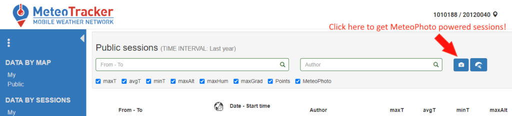
On the MeteoTracker dashboard, the MeteoPhoto enhanced sessions can be selected using the dedicated button highlighted in the image below.
0 Comments